Coropuna, the highest volcano in Peru
Coropuna, the highest volcano in Peru
What does Coropuna mean?
The name Coropuna comes from a Quechua word meaning puna or golden mountain. It was given this name because of its golden color, which shone like gold when it erupted.
History
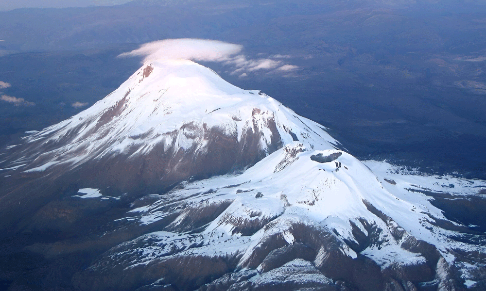
The Coropuna volcano is one of Peru’s sacred mountains and is covered in snow due to its altitude. At 6,425 meters, it is also one of the highest mountains in Peru, ranking third in height. It is so imposing that at the beginning of the last century, archaeologist Adolph Bandelier even claimed it was the highest mountain in South America.
It is an extinct (inactive) volcano, composed of six peaks and three lava flows from the Holocene epoch, all over 6000m high. The volcano is also the natural division between the Colca and Cotahuasi canyons, both considered in Peru to be the deepest in the world.
The first ascent to the summit of the Coropuna volcano was made by Hiram Bingham in 1911, via the western sector. The first Peruvian expedition to the western summit took place in October 1973 and was made up of national mountaineers Pablo Masías Núñez del Prado, José Zegarra Hidalgo, Adrián Puma Pampa, and Ubaldo Sucasaire Sihuacollo. The ascent of Alberto Parodi Isolabella in 1953 is also recorded, but to the southeastern summit.
The Incas, as on other volcanoes in the region, performed numerous religious ceremonies on it, offering human sacrifices near the summit.
Today, its summits are covered by a 50 km² glacier system with several dozen glacier tongues descending its slopes in a radial pattern.
It was one of the ritual centers of the Tawantinsuyu, which, calling it huaca, “worshipped” it (Andean offerings of reciprocity) for its eminence and beauty. It is mentioned by Garcilaso de La Vega and other chroniclers as one of the most important huacas in Condesuyo. There is even evidence of a sanctuary with ceramic remains and a body at the summit that was dynamited by looters, which was probably part of the Capacocha ritual.
Ecosystem
- This ecosystem is fed by water from the melting glacier cirque of the ravines, groundwater outcrops, and rainfall. It is characterized by dense, compact, evergreen vegetation with a cushion-like appearance. Distichia muscoides “champa” tends to dominate (although this is not conclusive), along with Plantago rigida “champa estrella” and other species.
- As you ascend to the summit of Coropuna, you can see species of wild flora that are indicators of overgrazing, such as “Cóndor Cebolla” (Werneria nubigena), “Garbancillo” (Astragalus sp.), ‘Acpul’ (Aciachne pulvinata), “Acelguilla” (Rumex acetosella), and the fauna of the area, such as alpacas, guanacos, vicuñas, llamas, and vizcachas. Typical flora such as ichu and yareta can also be seen.
Important
Coropuna has the largest water reserve in the form of a glacial cap among all Peruvian volcanoes, covering an area of 44.1 km². This important water resource benefits more than 90,000 inhabitants living in areas influenced by the volcano, whose main economic activities are agriculture and livestock farming.
Volcanic activity of Coropuna
According to INGEMMET, our country has 40 volcanoes, 10 of which are active.
One of them is Coropuna, in addition to Misti, Ubinas, and Ticsani, which have erupted in the last 10,000 years. For this reason, they are being monitored continuously.
Its last eruption was approximately 700 years ago, with lava flows reaching 7 km south of Coropuna, according to gob.pe.
Location
It is located 150 km northwest of the city of Arequipa, in the jurisdiction of the provinces of Condesuyos and Castilla.
Altitude
- 6425 meters above sea level
Nearby Excursions
- Misti Volcano
- Solimana Volcano
How to get to Coropuna Snow Mountain?
From Lima:
First, we must reach the city of Arequipa, either by land, by bus, which will take approximately 14 hours, or to save time, we can go by air, which takes only about 50 minutes.
From Cusco:
If you are planning to travel from Cusco to Arequipa, you have a few options to consider with different means of transportation:
- Flight (approximately 1 hour).
- Bus (approximately 11 hours).
- Taxi (approximately 8 hours).
Once in Arequipa, we must take a bus to the Cotahuasi Canyon, which will take us about 8 hours.
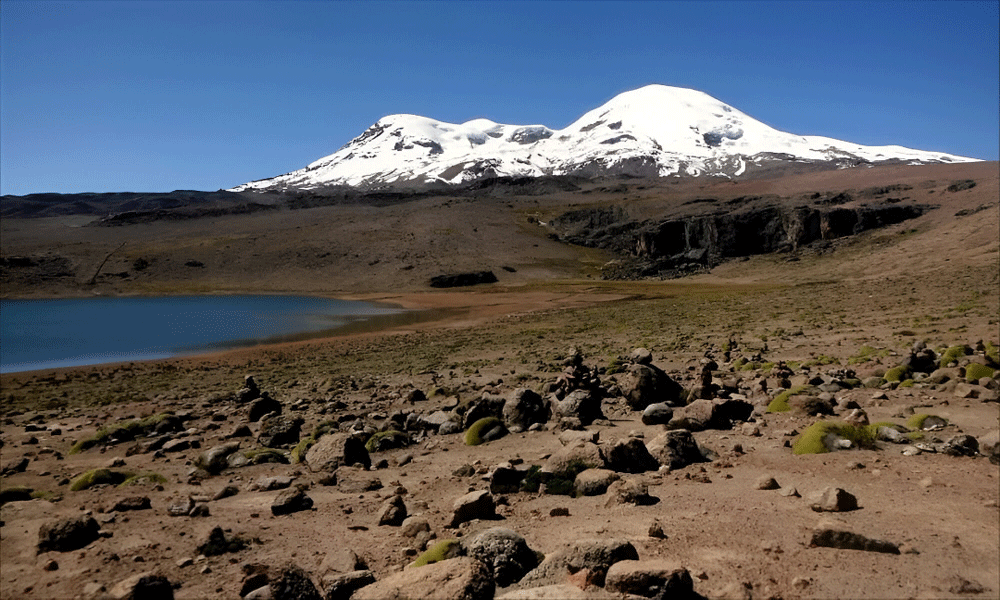
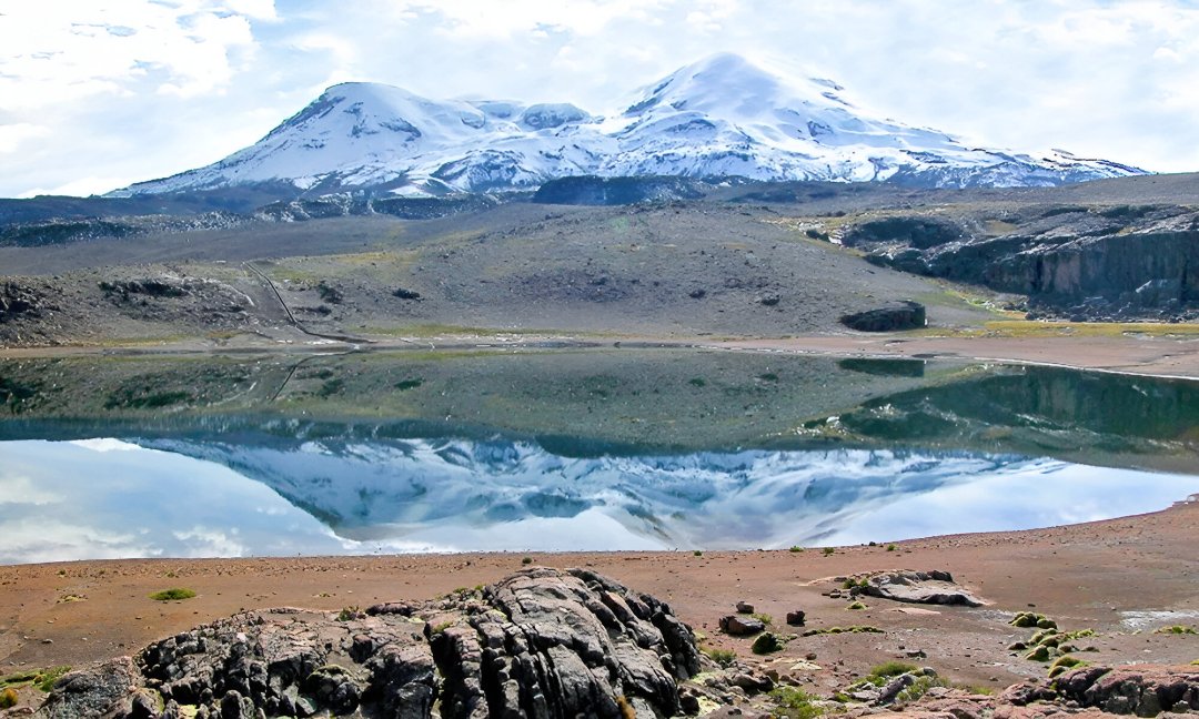
Then we arrive at the stunning Pallarcocha Lagoon, located at 4800 meters above sea level at the foot of Coropuna, where you can observe beautiful landscapes with a large number of birds.
We usually camp next to this lake to start the route to Coropuna the next day, which takes a couple of additional days, where we will first reach 5200 meters above sea level and on the last day we will reach 6425 meters above sea level in a 6-hour trek to the summit.
Ideal time to visit Coropuna
If you want to explore and climb the snow-capped Coropuna, the ideal season is between April and June, as the weather is dry and mild during this season, with sunshine during the day and cold nights, so you should bring appropriate clothing.
It is not recommended to do so during the rainy season between December and March.
Tour to Coropuna
As a travel agency, we offer you everything you need to have the best adventure on the highest mountain in southern Peru.
The ascent is carried out with experienced guides who know the route. It is necessary to have climbing equipment that includes ropes, poles, and crampons.
The climb is moderately difficult for a person in good health and acclimatized. However, if you do not have high mountain experience, it is advisable to start with the Misti or Chanchani volcanoes, also located in the department of Arequipa.